At work, I’m in the middle of the largest update of imagery I’ve ever supervised. Ten million square kilometers of new satellite views, covering most of the world’s most densely-populated areas and a whole bunch of other locations chosen ad-hoc for various reasons. The last update of this scale was five years ago, which means that - as I inspect the renderings and changes, I’m leaping between three and fifteen years into the future, in many cases over some momentous events. As such this month’s installment of Atlas Miscellaneous will consist of before/after comparisons.
Vyskryva, Ukraine
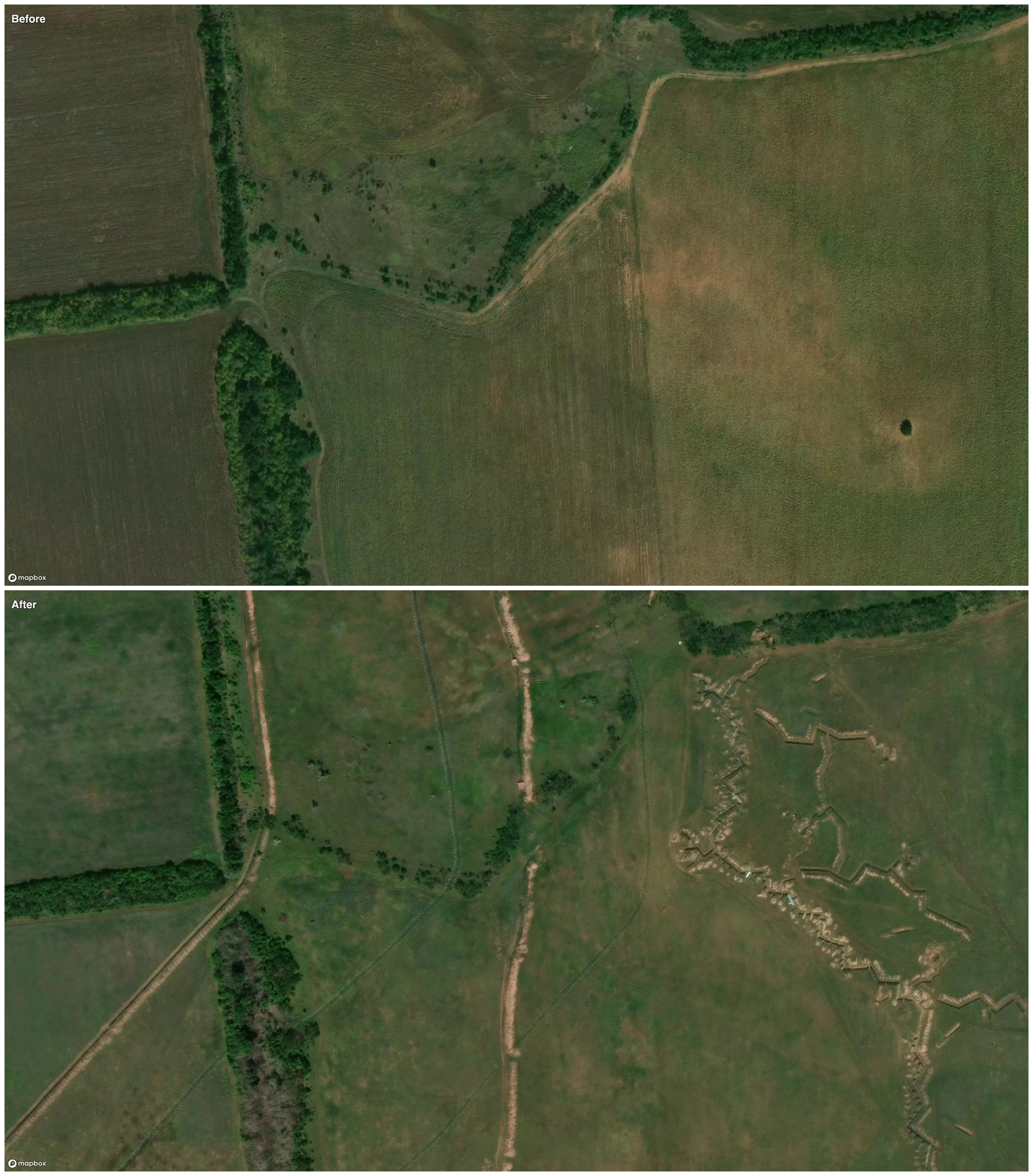
In 2018, this stretch of agricultural land on the Donetsk/Luhansk border in Ukraine was just beyond the reach of the long-simmering war between regional separatists and Kyiv. But Russian troops poured Westward through here in early 2022 before being pushed back by Ukrainian forces that same year. It was at this point that the Russians dug in firmly, in trenches behind rows of tank traps and concrete barriers. From here they would eventually advance to capture Bakhmut this year, leaving their Vyskryva fortifications in the ground. If the history of the First World War is any indication, the lines will be here for decades after peace allows the plows back into the fields.
Al Bayuk, Gaza
In the two years since Hamas attacked Israel and Israel began its retaliation, I’ve seen the regular use of satellite imagery by news organizations to demonstrate the destruction in Gaza. However, our current imagery update represents the first time that I’ve seen all of it at once. Our pre-existing coverage was from 2021, and now we have captures from 2024. The difference is shocking in the literal sense; I’m almost in an intellectual paralysis, and I don’t know what to do with the information I’ve gained.
The dwellings of Gaza have been leveled, from tents to apartment blocks, all up and down the relatively small region. The tactical movements of armored vehicles are written in the sand, and new earthen fortifications are everywhere among the rubble. But the aspect that I’m really having trouble grasping is visible just outside the Southern town of Al Bayuk:

It’s clear that most of the buildings here have been destroyed, with the exception of some greenhouses on the Eastern side, but in addition, crop fields and orchards have been plowed under. In some cases this looks methodical - several former groves show the lines of bulldozers running back and forth over them, like a combine harvester over corn. Why would they do that? Why would anyone do that? My brain breaks a little bit at that question, and doesn’t permit me to offer myself any speculative answers. It’s almost like a metaphorical sledgehammer taken to a common saying: how can you extend the olive branch of peace when the olive trees have all been destroyed?
Since the later image was captured, and indeed since the October 2025 ceasefire, more of the surrounding area has been leveled.
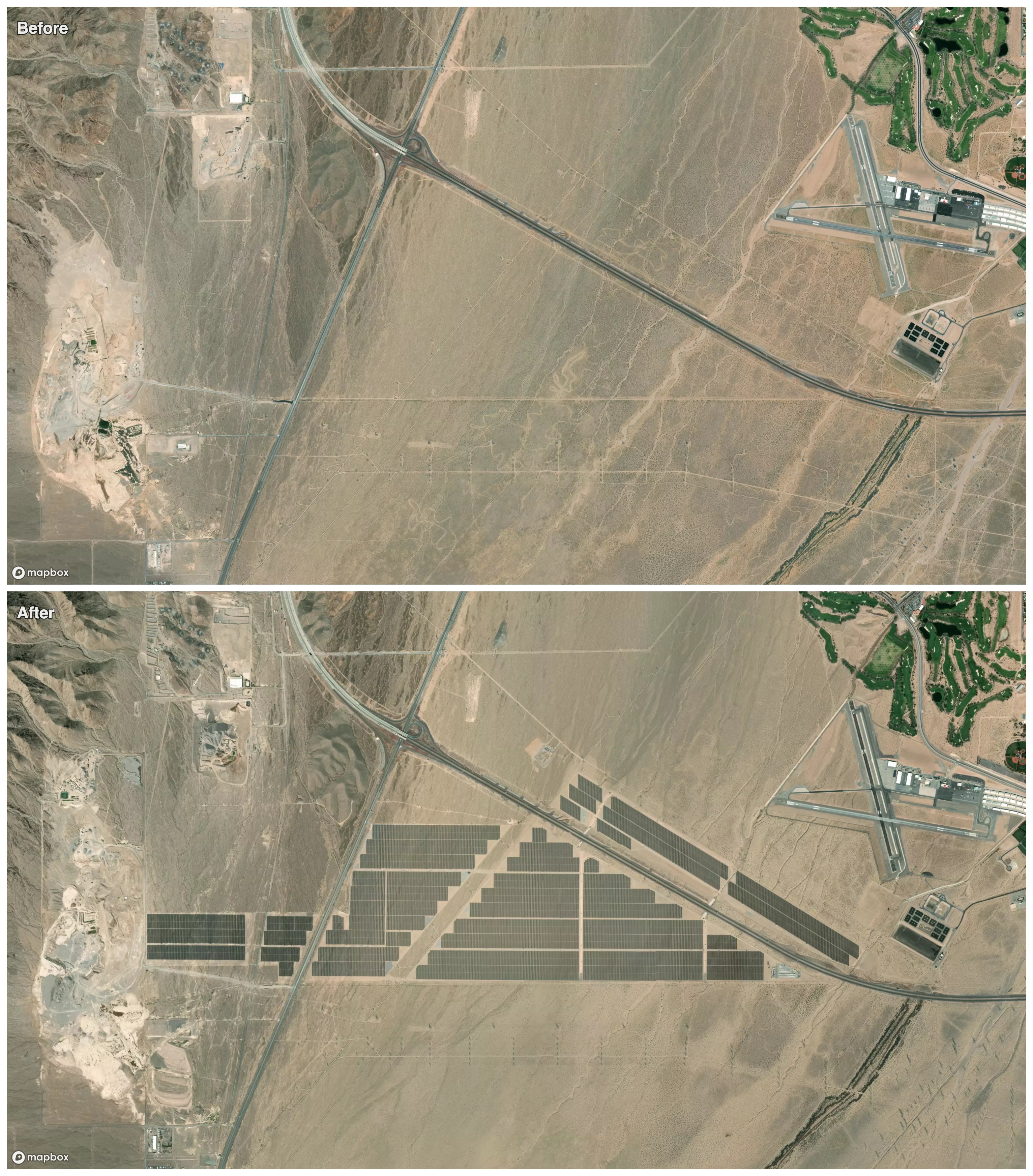
Boulder City, Nevada
Silver linings may seem in short supply these overcast days, so I was pleasantly surprised to read the news from Bill McKibben that solar power is, in fact, winning. That, as he puts it:
“It’s become cheaper to produce power from the sun and the wind than from setting stuff on fire.”
Solar generation capacity is now being installed at a global rate of 1 Gigawatt every day, and accelerating. I see the unmissable landscape effect of this everywhere in my QA work - in China most dramatically, but in Spain, Germany, Argentina, the Gulf states, even in Ukraine. Solar installations have appeared almost by magic in my update window. And here is one such project among many around the world, in political terrain I would not have thought of as friendly to renewable energy, sandwiched between a cluster of recreational gun ranges, some mines, and no fewer than four golf courses. 500 megawatts in the desert outside of Las Vegas, built within the last two years, and powering the future.
Cover image: Olive tree in full bloom, Spring of 1915 - G. Eric Matson